Cardall’s Corner – May 2018 – Linda Doyle
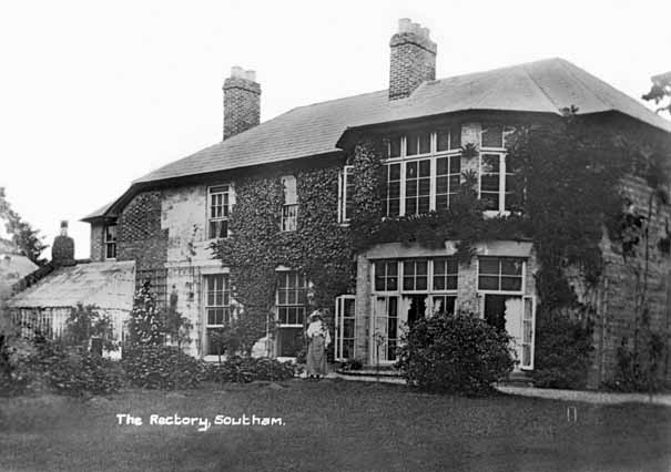
Over the years Southam town centre has had many changes, but one of the more dramatic was when the old Southam Rectory (see picture) was pulled down in the 1960s to make way for a new library, police station and magistrate’s court.
Originally the Rectory stood on a large plot of land on the corner of Park Lane, opposite St James’ Church. The tall garden wall hid the house from Market Hill and left the High Street in front of Lloyds Bank a very narrow road, with a row of terraced cottages against the footpath. Today, the low wall around Tithe Place, is all that remains of that original boundary.
The 1794 Rectorial Estate map surveyed for the Rev Sandy, Rector of Southam, shows the western end of the Rectory, where the Tithe Barn once stood, formed part of a much larger plot called The Park and was mainly undeveloped. The east boundary of the site bordered the High Street with a row of old buildings and pens. Fifty years later The Park appears unchanged, but the land to the east, now owned by the Rev Temple Hillyard, had heavily altered. It had been cleared of all previous structures, and this was where one large building stood in 1869 referred to as the Rectory House.
The Rectory was a large and mainly stone building, as were many of Southam’s old houses, with tall windows and two especially large bay windows at the rear looking onto well laid gardens and lawns. In keeping with many 19th century houses, the walls were covered in various creepers and it had a lean-to glasshouse off the rear wall. The 1888 map shows more outhouses and further west, a group of buildings that appear to be the Park Lane cottages of today. By now, a narrow terrace of buildings occupied the north-east corner of the site. These buildings were later demolished after a WW2 tank managed to damage the end one of the row, the others being unoccupied and in a state of disrepair. Later they were all demolished.
One Southam Rector who lived there from the late 19th Century was Rev John Hart-Davies whose son, Lieutenant Ivan Beauclerk Hart-Davies, set the Land’s End to John O’Groats motorcycle record in 1911 on a Triumph in 29 hours 12 minutes. He had been an important pre-WW1 pioneer motorcyclist, but by then was an insurance-broker living in Rugby. His first achievement for the record had been two years earlier in 33 hours 22 minutes.
When he joined No 35 Training Squadron Royal Flying Corps during WW1, Hart-Davies’ idea had been to establish another Land’s End to John O’Groats record – this time by air. Sadly, he was killed aged 39 on 26th July 1917 in a flying accident at Bristol on the eve of going to the front. He was brought home to be buried at St James’ Church on the 31st July. His father John had died only two months earlier and had also been buried at Southam.
On a lighter note, at the start of WW2 in 1939, during the blackouts someone kept moving advertising signs and a ‘certain brand of wine’ advert was frequently moved from the High Street to outside the Rectory entrance!
To find out more about local history, contact Southam Heritage Collection. Please see our website www.southamheritage.org for details of our location, exhibitions and current opening times. Contact: 01926 613503 email southamheritage@hotmail.com and find us on Facebook: Southam Heritage Collection
Leave A Comment